

Weather Fronts
Introduction of Cold, Warm, Stationary Weather Fronts: What is Occluded Front?
Feb
An occluded front forms when a warm front is overtaken by a faster-moving cold front. Occluded fronts usually form around a low pressure area, where the cool air mass catches up to and lifts the warmer air mass. The formation of an occluded front can lead to complex weather patterns, as the air masses interact.
There are two types of occlusions: cold occlusion, where the air ahead of the warm front is warmer than the air behind the cold front, and warm occlusion, where the air ahead of the warm front is warmer than the air behind the cold front.The weather along an occluded front can vary depending on the temperature differences between the air masses.
Precipitation is often more significant along the cold front portion of the occlusion. Occluded fronts often bring cloudy skies, precipitation, and shifting winds.
On a traditional weather map, an occluded front is indicated on a weather map by a purple line with alternating triangles and semi-circles in a traditional weather map representation.
The direction of travel of an occluded front is typically towards the center of the low pressure system.
As the occlusion process continues, small isolated occluded fronts often form and dissipate. These isolated occluded fronts often remain active for short periods before dissolving.
The surface of the occluded front and its projection on the earth’s surface can be complex, making forecasting challenging. For more detailed information on occluded fronts and their impact on aviation, refer to the Skybrary aviation safety resources.
Weather fronts are essential components of meteorology, representing the boundaries between different air masses.
Understanding these fronts, particularly the occluded front, provides insight into various weather phenomena. This article will explore the definitions, characteristics, and implications of cold, warm, stationary, and occluded fronts, helping readers grasp their significance in daily weather patterns and forecasts.
Understanding Weather Fronts
Understanding weather fronts is crucial for predicting atmospheric conditions. An occluded front occurs when a cold air mass overtaking the warm air mass catches up to a cold or warm front.
The cool air mass overtaking the warm air plows under both air masses, creating a complex system. On a weather map either a purple line or a line with alternating triangles and semicircles indicates the location of the occluded front.
The air behind the front is colder than the air ahead of the front. This can create cloudy conditions with patchy precipitation. In some cases, cold core funnel clouds are possible.
The occluded front forms when the colder air mass while lifting the warmer air, rides over the colder air at the surface. The air near the earth’s surface of the occluded front is typically colder than the cool air above it but warmer than the cold air behind the front.
What are Weather Fronts?
Weather fronts are defined as the transitional zones between two different air masses, characterized by distinct temperature and moisture differences. These fronts can be categorized as cold, warm, stationary, or occluded, each influencing the weather in unique ways. A cold front occurs when a cold air mass pushes into a warm air mass, while a warm front happens when warm air overtakes a cold air mass. Stationary fronts occur when neither air mass advances, leading to prolonged weather conditions. Understanding these distinctions is crucial for interpreting weather maps and predicting weather patterns.
Why are Weather Fronts Important?
Weather fronts play a pivotal role in shaping local and regional climates, as they are often associated with significant weather changes.
They can lead to the development of clouds, precipitation, and various storm systems. For instance, cold fronts typically bring thunderstorms, while warm fronts can lead to steady rain.
Recognizing the importance of these fronts helps meteorologists provide accurate forecasts, which are essential for agriculture, transportation, and disaster preparedness.
As such, understanding weather fronts is vital for both scientific study and everyday life.
How Do Weather Fronts Affect Climate?
The interaction of different air masses at weather fronts significantly impacts the climate of a region.
For example, cold fronts can introduce colder air, leading to drops in temperature, while warm fronts bring warmer air and can increase humidity levels.
These changes can influence local ecosystems, agriculture, and even human health.
Moreover, the frequency and intensity of weather fronts in a given area can determine long-term climate patterns, such as whether a region experiences more storms or milder weather.
Thus, weather fronts are integral to understanding both immediate weather conditions and broader climatic shifts.
Types of Weather Fronts

What is a Cold Front?
A cold front is formed when a cold air mass moves into an area occupied by a warmer air mass, causing the warm air to rise rapidly. This process can lead to the development of cumulus clouds and often results in precipitation, including thunderstorms. The temperature drop associated with a cold front can be quite significant, and the transition zone is usually marked by a steep gradient in temperature. On a weather map, cold fronts are typically represented by blue lines with triangles pointing in the direction of the front’s movement, indicating the arrival of cooler air.
How does a Cold Front form?
The formation of a cold front occurs when a cold air mass advances into a region of warmer air. As the colder, denser air pushes forward, it forces the warm air to rise, leading to cooling and condensation. This process can create clouds and precipitation, often resulting in severe weather conditions. The abrupt lifting of warm air can also lead to the formation of thunderstorms, which are common along cold fronts. Understanding this formation process is crucial for predicting the type of weather that may occur when a cold front passes through.
What weather patterns are associated with Cold Fronts?
Cold fronts are often associated with dramatic weather changes, including a sudden drop in temperature and shifts in wind direction. As the front passes, clouds typically form quickly, leading to precipitation that can range from light rain to heavy thunderstorms. After the front passes, skies often clear, and temperatures drop, creating a distinct contrast with the weather conditions that preceded it. This rapid change in weather is a hallmark of cold fronts and is essential for meteorologists to monitor for accurate weather forecasting.
What is a Warm Front?
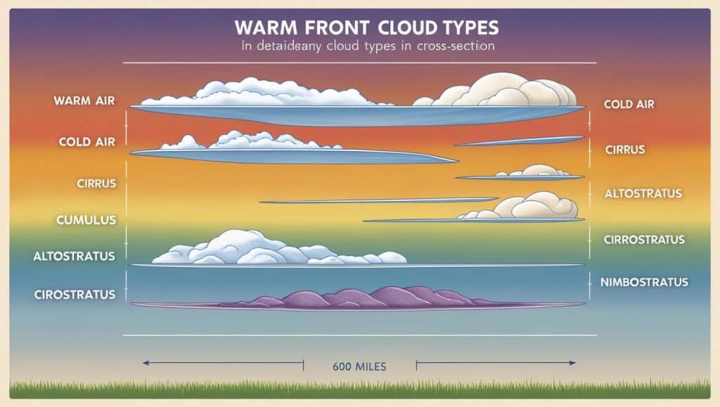
A warm front occurs when a warm air mass moves into an area occupied by a colder air mass, causing the warm air to rise gradually over the cooler air. This gentle ascent leads to the formation of stratus clouds and often results in prolonged precipitation. On a weather map, warm fronts are indicated by red lines with semicircles pointing in the direction of the front’s movement, signifying the approach of warmer air. Understanding warm fronts is crucial for predicting weather patterns, as they can lead to extended periods of rain and milder temperatures.
How does a Warm Front form?
The formation of a warm front takes place when a warm air mass moves towards a cold air mass. As the warm air rises, it cools and condenses, forming clouds that can lead to steady rain. Unlike cold fronts, which can create severe weather quickly, warm fronts tend to produce more gradual weather changes. This process can result in overcast skies and prolonged periods of precipitation, making it essential for meteorologists to recognize and track warm fronts for accurate weather predictions.
What weather patterns are associated with Warm Fronts?
Warm fronts are typically associated with gradual weather changes, including increasing temperatures and prolonged rainfall. As the warm air rises over the cooler air, cloud formation occurs, often leading to widespread stratus clouds and light to moderate precipitation. This weather pattern can last for several days, resulting in moist conditions that can affect agriculture and outdoor activities. Understanding the characteristics of warm fronts is crucial for predicting the type of weather that may occur as they approach and pass through a region.
What is a Stationary Front?
A stationary front occurs when two air masses meet but neither advances, leading to a prolonged period of similar weather conditions. This type of front can result in extended periods of cloudiness and precipitation, as the air masses remain in place. On weather maps, stationary fronts are depicted as alternating red semicircles and blue triangles, indicating the presence of both warm and cold air. Recognizing stationary fronts is essential for understanding weather patterns, especially in regions where they frequently occur.
How does a Stationary Front differ from Cold and Warm Fronts?
Unlike cold and warm fronts, which involve the movement of air masses, stationary fronts occur when neither air mass is dominant, leading to a standstill. This can result in prolonged weather conditions, such as cloudy skies and persistent precipitation. Stationary fronts can lead to flooding and other weather-related issues if they remain in place for an extended period. Understanding these differences is vital for meteorologists when forecasting weather and assessing potential impacts on local conditions.
What weather conditions are typical for Stationary Fronts?
Stationary fronts are often associated with extended periods of cloud cover and precipitation, as the air masses involved do not move significantly. This can lead to persistent rain or drizzle, affecting visibility and travel conditions. Additionally, stationary fronts can contribute to localized flooding if they remain in one area for too long. Recognizing the signs of a stationary front is essential for accurate weather forecasting, as it can help predict prolonged wet conditions and their potential impacts on daily life.
What is an Occluded Front?
How does an Occluded Front form?
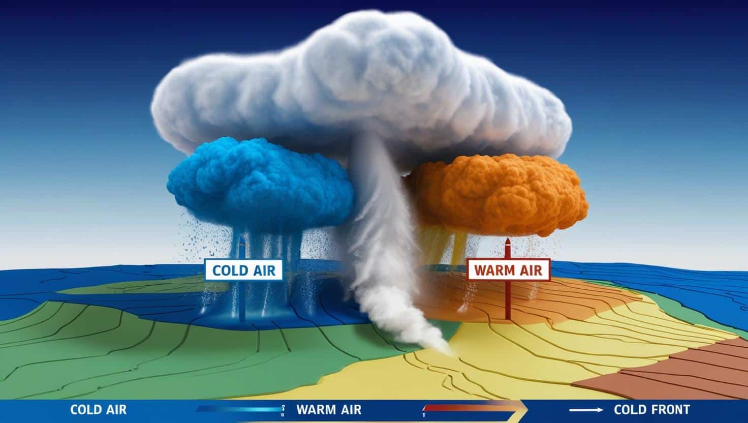
An occluded front forms when a cold front overtakes a warm front, resulting in the warm air mass being lifted off the ground. This process typically occurs in areas of low pressure, where the colder air masses push against the warm air, leading to complex interactions. Occluded fronts are characterized by a mix of cold and warm air, often resulting in varied weather patterns. On a weather map, occluded fronts are represented by a purple line with alternating semicircles and triangles, indicating the merging of different air masses.
What are the characteristics of an Occluded Front?
Occluded fronts are unique in that they combine elements of both cold and warm fronts, leading to complex weather patterns. They often produce a mixture of precipitation types, including rain, snow, or even thunderstorms, depending on the temperature of the air masses involved. The surface weather associated with occluded fronts can vary significantly, with changes in wind direction and temperature. Understanding these characteristics is crucial for meteorologists to predict the potential impacts of occluded fronts on local weather conditions.
Comparing Weather Fronts
How do Cold, Warm, and Occluded Fronts differ?
Cold, warm, and occluded fronts differ primarily in their formation and the resulting weather conditions. Cold fronts occur when cold air pushes into a warm air mass, leading to rapid weather changes, while warm fronts involve warm air overtaking cold air, resulting in gradual weather shifts. Occluded fronts, on the other hand, form when a cold front overtakes a warm front, creating a complex mix of air masses. Understanding these differences is crucial for accurate weather forecasting and predicting the type of weather that may occur.
What are the similarities between these types of fronts?
Despite their differences, cold, warm, and occluded fronts share some similarities. All types of fronts represent boundaries between different air masses and can lead to significant weather changes, including precipitation and shifts in temperature. Additionally, they are all associated with low-pressure areas, which can intensify the weather patterns they produce. Recognizing these similarities helps meteorologists understand the broader impacts of weather fronts on local and regional climates.
Why is it important to understand these differences?
Understanding the differences between cold, warm, and occluded fronts is crucial for accurate weather forecasting and preparedness. Each type of front can lead to distinct weather patterns, which can impact daily life, agriculture, and transportation. By recognizing the characteristics of these fronts, meteorologists can provide better forecasts, helping individuals and communities prepare for potential weather-related challenges. This knowledge is essential for effective disaster preparedness and response strategies.
Real-World Implications of Weather Fronts
How do Weather Fronts impact daily weather forecasts?
Weather fronts play a significant role in shaping daily weather forecasts, as they are often the driving force behind changes in temperature, precipitation, and wind patterns. Meteorologists rely on the identification and analysis of these fronts to predict weather conditions accurately. For instance, the arrival of a cold front may signal an impending storm, while a warm front could indicate a period of stable weather. By understanding weather fronts, individuals can make informed decisions about their daily activities, from outdoor plans to travel arrangements.
What role do Weather Fronts play in severe weather events?
Weather fronts are often associated with severe weather events, including thunderstorms, tornadoes, and blizzards. Cold fronts, in particular, can trigger intense storms as warm air is rapidly lifted, leading to the formation of cumulonimbus clouds. Occluded fronts can also contribute to severe weather by combining cold and warm air masses, resulting in complex weather systems. Understanding the role of weather fronts in severe weather events is crucial for issuing timely warnings and ensuring public safety during hazardous conditions.
How can understanding Weather Fronts help in disaster preparedness?
Understanding weather fronts is vital for disaster preparedness, as it allows individuals and communities to anticipate and respond to changing weather conditions. By recognizing the signs of approaching fronts, people can take proactive measures to protect themselves and their property. For example, knowing when a cold front is approaching can prompt individuals to secure outdoor items and prepare for potential storms. Additionally, communities can develop response plans based on the expected impacts of different types of fronts, enhancing overall resilience to weather-related disasters.
Conclusion
An occluded front simply occurs when a faster moving cold front catches up to and overtakes a warm front.
This results in the cold front plowing into the warm air mass while lifting the warm air off the ground. The occluded front appearing on a weather map either by a purple line with alternating semicircles and triangles indicates where the front is shown.
There are two types of occluded fronts: warm and cold.
The type of occluded front depends on whether the air behind the faster moving cold front is colder or warmer than the air ahead of the warm front.
The associated weather with an occluded front can be complex, often leading to stormy weather. However, significant changes in temperature and precipitation are not really common.
The shear is significant along the front, and this can lead to turbulent conditions. As the front moves, it is often associated with a drying trend as the mass overtaking the warm front stabilizes.
Understanding the dynamics of these two fronts helps in predicting the related weather patterns when such a front is moving through an area.